Using GIS to Support Equitable Community Development
By bitsadmin
From revealing data patterns and trends to streamlining collaborative planning efforts, Geographic Information Systems (GIS) technology has revolutionized our ability to display and analyze spatial information. First developed in the 1960s, this rapidly evolving technology plays an essential role in community development, informing urban design and infrastructure planning decisions. Importantly, GIS provides a unique framework to highlight patterns of inequity and support the development of more equitable communities.
In recent years, GIS has become an invaluable tool for identifying and visualizing patterns of social inequity within communities, including income disparities, access to public transit, proximity to environmental hazards, access to recreation opportunities, and other social issues that have a geographic footprint. Leveraging GIS data to create maps that highlight these disparities provides decision-makers with the critical information they need to develop equitable solutions in their communities.
Parks and open spaces are a tangible reflection of the quality of life in communities that provide economic value and positive health impacts. Insufficient access to these resources negatively impacts communities leading to hotter temperatures, increased air pollution, more frequent flooding, and poor health. To help mitigate these outcomes, Seattle-based engineering firm, Herrera Environmental Consultants, uses GIS in innovative ways to support urban development and parks projects through an equity-focused lens.
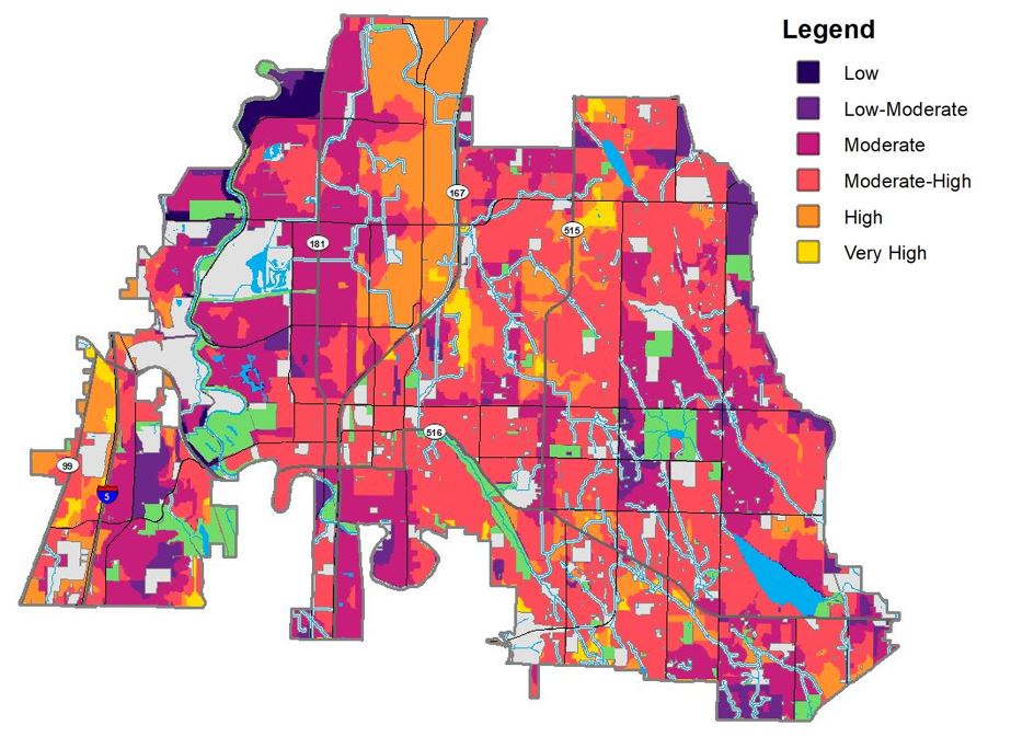
Heat map created using GIS to highlight areas where projects are most needed and provide the most benefit.
Currently, Herrera is providing GIS support to the City of Kent; which recently ranked as the tenth most ethnically diverse city in the nation. To better and more equitably serve current and future residents, the City of Kent is updating its Parks and Open Spaces Plan to guide the continued development of the overall park system.
To help the City prioritize their investments, Herrera developed a series of maps that characterize existing park access and park need by ranking and overlaying datasets such as demographics, health outcomes, walking distance to parks, park recreational values, population density, public transportation, and other key factors. This resulted in a set of “heat maps” highlighting areas where projects would provide the most benefit with an emphasis on prioritizing investments in traditionally underserved communities. By sharing this data with the community through interactive StoryMaps, stakeholders gain a better understanding of the process and an opportunity to provide input ensuring results align with the lived experiences of community members.
Similarly, Herrera is working with the City of Lynnwood to help develop their Equitable Park Access Plan. This plan will provide a long-term vision for parks, recreation, trails, and open space while also functioning as an action plan for capital project implementation for the next 10 years. Herrera is applying GIS technology on this community-led, equity-based project, helping to quantify existing park access, need, and equity mapping. GIS datasets are the basis for heat maps focused on park access and racial and social equity. Once the park access and racial and social equity maps are completed, Herrera will overlay the maps with climate change vulnerability and other key datasets to develop the park need composite map.
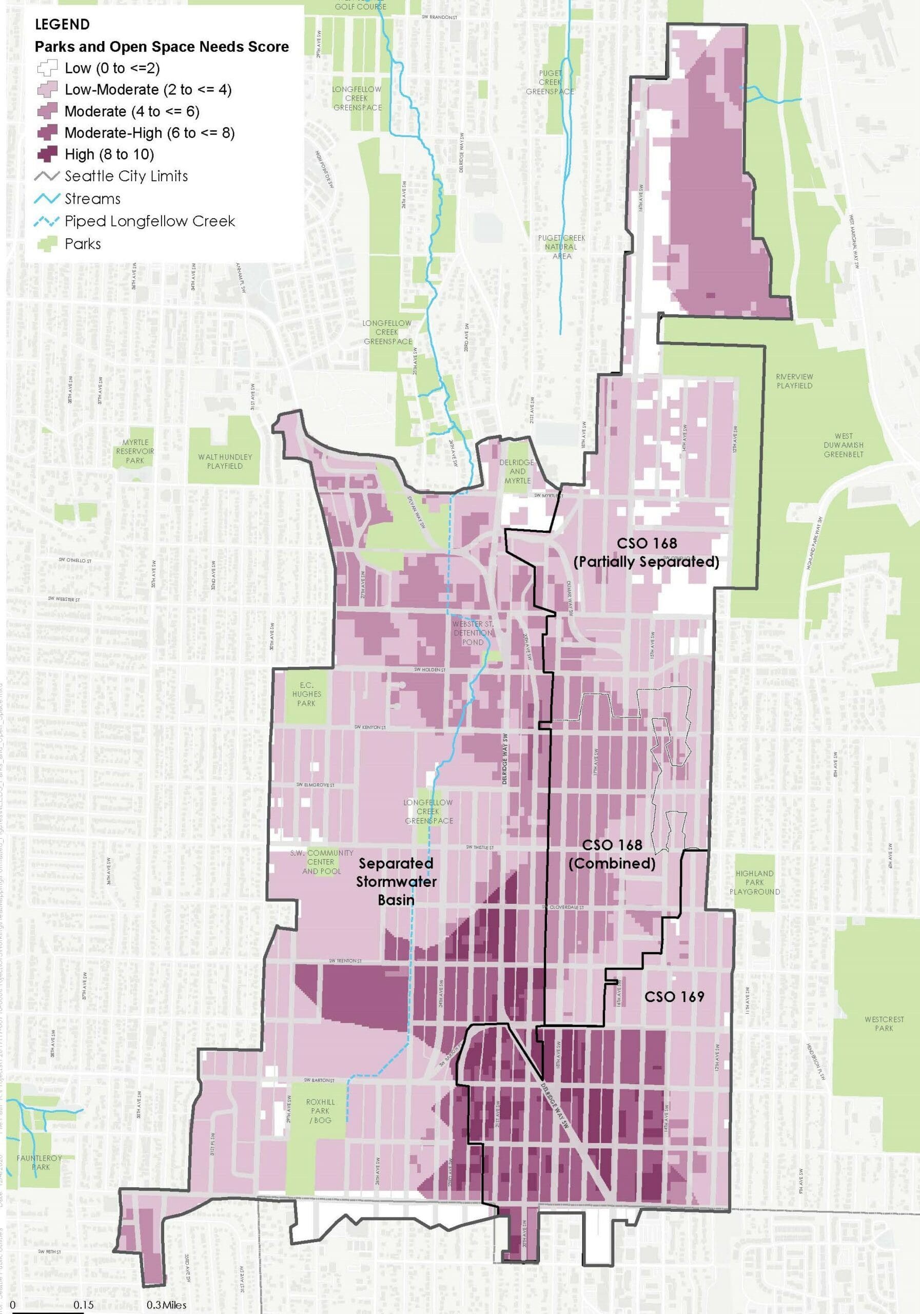
Map created using GIS for Longfellow Starts Here project to identify areas of park need
Likewise, Herrera continues to utilize GIS in our work with the City of Seattle to center equity in infrastructure improvements. Seattle Public Utilities’ (SPU) Longfellow Starts Here project places community-centered planning and racial equity at the forefront of its execution. This project focuses on improving water quality in Longfellow Creek by reducing combined sewer overflows and treating stormwater runoff, while maximizing community benefits.
To help SPU identify opportunity areas through an equity lens, Herrera used GIS datasets to create eleven multivariable maps in multiple analysis categories consisting of Needs and Feasibility. Through this work, Herrera synthesized dozens of spatial datasets into easy-to-read maps. Needs multivariable maps highlight areas of need for improved community mobility, parks access, or opportunities for collaboration between SPU and other City departments to achieve multi-benefit projects. Racial and social equity mapping was also part of the Needs mapping, which included synthesizing race and ethnicity, socioeconomic status, and health data into a block group-level vulnerability score. Feasibility multivariable maps highlight potential areas to implement SPU infrastructure. By overlapping these maps, SPU can easily identify the best locations to focus on detailed technical and partnership analyses to stretch capital dollars.
Using these maps, a series of workshops were held with a community-based Integrative Design Team to share information regarding existing conditions. Through this data, patterns of need were more easily identified compared to looking at multiple individual datasets. In addition, this process recognizes the common reduction and racialization of data, emphasizing the need for spatial analysis to be grounded in the experience of the community while promoting discussion of the causes of inequities.
To address this, Herrera identified and mapped Community Need as part of this workshop effort, overlaying datasets to help “truth” the other maps and center equity and community priorities. The Integrative Design Team also provided feedback on other heat maps and the metrics used to develop them in an iterative process.
By transforming geospatial datasets into easy-to-read maps and actionable insights, resources are better allocated across communities, promoting racial equity and social justice for years to come. Industry experts anticipate increases in innovative GIS and other technology used to identify and address inequities through mapping and spatial analysis.
When asked about the importance of GIS to address inequalities, Herrera spatial science manager, Jenn Schmidt states:
“By using GIS data to better understand patterns in the community, we are helping to provide decision-makers with the information that they need to center equity in how they plan projects and allocate resources. When we build these analyses in collaboration with the community, we stand the best chance of working together to help create long-lasting change.”
These efforts continue to make a difference in a wide range of urban development projects across Washington State. Herrera has enjoyed supporting our client’s efforts to identify projects that have the greatest impact on future generations.
Author’s Note: This article was originally published in Seattle DJC’s August 2022 Special Sections: Urban Development edition.
Posted In:
Community, Innovation, Sustainability, Technology, Uncategorized, Washington