Telling Stories Through Interactive Deliverables
By bitsadmin
ArcGIS StoryMaps, Hubs, and Experiences are web-based multimedia applications that allow municipalities, nonprofits, and other organizations to share spatial stories with communities and other stakeholders. Through interactive maps, charts, dashboards, and other media, these tools bridge the gap between municipalities and community members to help our clients make cost-effective, real-world decisions. Using these tools, environmental professionals can better illustrate spatial relationships to promote engagement and collaboration with internal and external stakeholders. Herrera uses these applications in our infrastructure projects to create informative, interactive deliverables that promote impactful decision-making. Learn more about our use of these cutting-edge GIS technologies below.
Increasing Community Engagement through ArcGIS Applications
Community engagement played an integral role in Herrera’s project with the City of Kent to provide GIS analysis support for the City’s Parks and Open Spaces Plan update. To ensure Plan updates better and more equitably serve current and future residents, Herrera used GIS technology to develop “heat maps” highlighting areas where projects would provide the most benefit with an emphasis on prioritizing investments in traditionally underserved communities. Using this data, Herrera developed an interactive Hub site with embedded StoryMaps explaining the Plan’s purpose, goals, and outcomes. By simplifying data visualization and creating transparency around the GIS process, community members can better understand how updates to the City’s plan align with their lived experiences.
Using StoryMaps to Educate Broad Audiences
When conveying data to an audience with a broad range of technical backgrounds, ArcGIS web applications help clients present information in an intuitive, graphic-rich layout. Herrera utilized these applications in our project with the Washington Department of Fish and Wildlife to guide the future protection and restoration of beach systems in Puget Sound.
Through this multi-phase project, Herrera incorporated feedback from end-users to develop an online mapping tool, referred to as the Beach Strategies Tool, helping restoration professionals develop management recommendations at a desired scale of analysis, investigate underlying data used to develop management recommendations, and specify ranges of user-defined values.
To help users of differing technical backgrounds learn how to use the Beach Strategies tool, Herrera created outreach curriculum in the form of an ArcGIS StoryMap. The interactive site contains tools and guidance materials for data stewardship of the shoreline armor, forage fish spawning, and beach strategies data.
As part of these tools/guidance materials, Herrera developed a Stewardship Workflow ArcGIS Pro Toolbox which provides models and in-depth descriptions of how to perform the updates to the shoreline armor data and associated Beach Strategies database. In addition, the site includes a downloadable standardized geodatabase template to allow for optimal data collection of new shoreline armor mapping, a Users’ Guide featuring information on how to collect new shoreline armor data, how to use the Stewardship Workflow ArcGIS Pro Toolbox, and recommendations on building a data update plan. Through navigating the StoryMap, users of various backgrounds become familiar with the Beach Strategy Tool’s capabilities to better identify potential restoration and conservation actions within the region.
Using ArcGIS Applications for Comprehensive Plans and Stormwater Management Action Planning
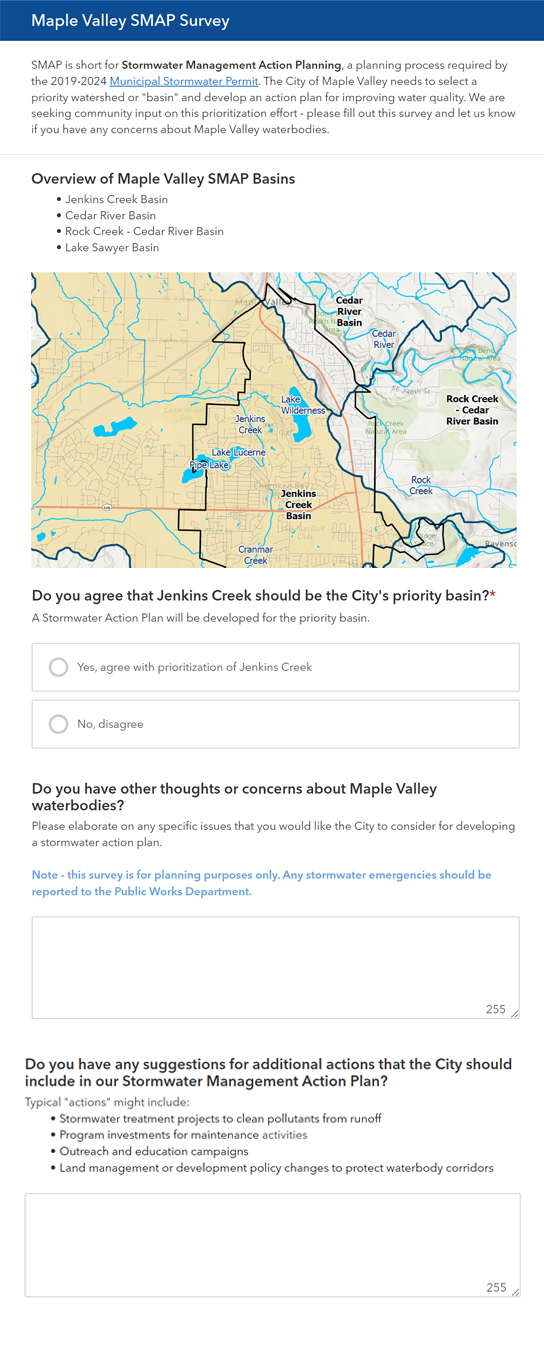
ArcGIS StoryMaps may also help clients better inform and collect input from community members and stakeholders while developing stormwater in Herrera’s project with the City of Maple Valley to develop a Storm and Surface Water Comprehensive Plan that will identify stormwater-specific actions the City should take in the next 10 years to address current surface water issues, protect natural resources, and plan for future development.
comprehensive plans that involve Stormwater Management Action Planning (SMAP) prioritization. These applications were used
Through this project, the team developed a StoryMap to provide the public with an overview of the Storm and Surface Water Comprehensive Plan and the Stormwater Management Action Planning (SMAP) process. Part of the SMAP process involves selecting a priority watershed or “basin” and develop an action plan for improving water quality. To better identify areas where stormwater projects best meet community and environmental needs, Herrera integrated a public SMAP survey into the StoryMap. Through this survey, community members were asked to place a point on an interactive map to indicate locations where stormwater and watershed projects would provide the most benefit. To provide more context, survey participants may leave a comment describing water-related issues within the area. By consolidating these comments, environmental professionals can better assess potential solutions to include in the overall Comprehensive Plan.
As illustrated above, the utilization of ArcGIS web applications remains crucial in the effective engagement of stakeholders to implement practical infrastructure solutions. Herrera continues to harness the power of innovative GIS technology, helping our clients better connect with the communities they serve.
For more information on these projects, please contact Jenn Schmidt, GISP, Lauren Ode-Giles, or Katie Wingrove, PE.
Posted In:
Community, Sustainability, Technology, Uncategorized, Washington